
More than a decade after a powerful quake devastated Haiti in 2010, the region's complex geology has sent the island into yet another spate of deadly convulsions. An intense magnitude 7.2 earthquake rocked Haiti in the morning hours of August 14, some 46 miles west of the 2010 temblor.
Both quakes are part of Haiti’s long history of shakes, which results from the island nation’s position at the edge of the slowly shifting Caribbean plate. The movements build stresses in a network of fractures that crisscross the island, which occasionally release pent-up stress in ground-rattling earthquakes. While the region's quakes are not the most powerful in the world, their deadliness is magnified by Haiti's abundance of concrete and masonry buildings that were not built to withstand earthquakes.
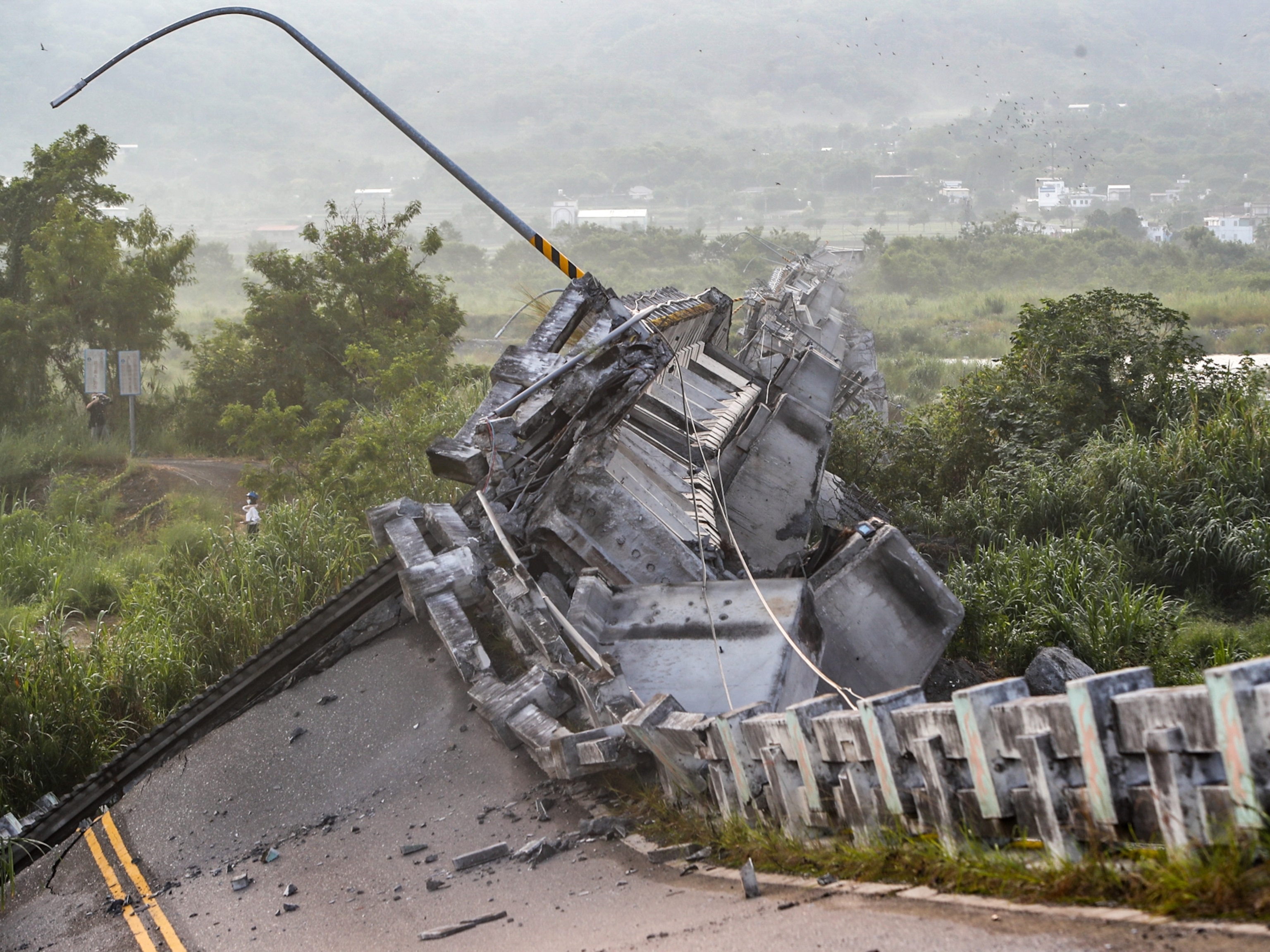
The full impacts from this latest event are not yet clear, but the quake likely wreaked havoc in communities that are already struggling from multiple pressures. The country is still recovering from the 2010 earthquake, which struck closer to the capital city Port-au-Prince, flattening many buildings and causing more than 200,000 deaths. It will take time for officials to determine how many people were killed in this latest event, but the U.S. Geological Survey estimates fatalities could number in the thousands.
The shaking was intensely felt in the cities of Les Cayes and Jeremie—both of which are still recovering from Hurricane Matthew in 2016, which battered the island with 145-mile an hour winds, significant floods, and downpours of rain. This new disaster also strikes as the country is still reeling from the assassination of President Jovenel Moïse on July 7.
"They just have one thing after the other," says Susan Hough, a geophysicist at the United States Geological Survey.
Constantly shifting tectonics
The island of Hispaniola, which includes the countries of Haiti and the Dominican Republic, sits atop the Caribbean tectonic plate, which is surrounded by a sea of other plates. Between the jostling of the North American, Cocos, South American, and Nazca plates, the Caribbean plate is constantly shoved and squashed by tectonic movements.
The key juncture that sparks shaking on the surface in Haiti lies just to the north of the island nation, where the Caribbean plate creeps eastward roughly three-quarters of an inch each year relative to the North American plate. Yet the boundary between the plates is not one straight fracture.
As the plates grind against each other, the forces produce a series of fractures that crisscross the region. Both the 2010 event and this latest quake—as well as multiple older quakes—occurred within one set of these breaks, which are known collectively as the Enriquillo-Plantain Garden fault zone.
Scientists believe that the 2010 event is likely connected to today's temblor. "An earthquake releases stress, but it also nudges—pushes—nearby faults in a way that makes other earthquakes more likely," Hough explains.


Analyses of the region after the 2010 temblor suggested that the shifting of the surface increased stresses both eastward toward Port-au-Prince and westward toward the epicenter of today's magnitude 7.3 quake, says Newdeskarl Saint Fleur, a geophysicist at the University of Haiti currently based in Paris, who is the lead author of a 2015 study that modeled these stress changes. Hough adds that a similar increase in stress on faults in this area was seen during the 1700s, when a spate of earthquakes struck in 1701, 1751, and 1770.
Stress also tends to accumulate most at bends or curves in the faults, Saint Fleur says, and today's event seemed to strike at one such bend. The epicenter is near the site of the 1770 quake, which, at an estimated magnitude 7.5, is the largest known to ever strike within this fault zone.
Yet even with this information, it's still not possible to predict quakes, Hough notes. "We see the patterns after the fact, and we say okay this domino nudged this domino," she says. But "there's no way to know which domino might go next."
A nation under strain
While the region has a history of shakes, the temblors in Haiti are not as large as those that occur where one plate plunges beneath another in what’s known as a subduction zone. One such quake, clocking in at a magnitude 8.2, recently shook Alaska's Aleutian Islands.
But the Aleutian Islands are sparsely populated, so that quake caused little damage. The deadliness of quakes in Haiti is the result of the structures on the surface as much as the shaking underground. Years of exploitation from outside countries, dating back to the enslavement of the island’s people after Christopher Columbus arrived in 1492, and political unrest within Haiti have resulted in the country’s current standing as the poorest in Latin America.
The unrest and poverty have translated to the development of the region, which is rife with substandard structures and building materials. Many structures use concrete, which is inexpensive and can be used to create heavy walls and roofs that resist hurricane winds, Hough says. But much of the region's concrete is unreinforced, and it readily crumbles under the shaking of earthquakes. While rebuilding after the 2010 devastation led to some structures built with earthquakes in mind, corruption and political turmoil have stymied many efforts to rebuild.
"The construction in Haiti is just like a perfect storm of unfortunate factors," Hough says. "It's everything you don't want in an earthquake."
The blow of this latest event, however, may have been blunted by the direction in which the earthquake traveled. The quake appears to have traveled westward, which means the most intense shaking was directed away from the densely populated city Port-au-Prince. Still, modeling from the U.S. Geological Survey suggests that landslides will be a significant hazard, barreling into structures, blocking roads, and limiting access for recovery crews.
Aftershocks will continue to rattle the region, and scientists will be keeping close watch on the sequence of shakes. After the 2010 earthquake, Hough was part of a team of scientists that traveled to Haiti to install seismometers. She returned in the subsequent years to help establish an earthquake monitoring network and, she says, is working now to figure out "what we can do to support this fledgling network and this community."
Editor's note: This article has been corrected to clarify that the 1770 earthquake was the largest within the Enriquillo-Plantain Garden fault zone, not the largest in Haiti’s history.
Related Topics
You May Also Like


Go Further
Animals
- Octopuses have a lot of secrets. Can you guess 8 of them?
- Animals
- Feature
Octopuses have a lot of secrets. Can you guess 8 of them? - This biologist and her rescue dog help protect bears in the AndesThis biologist and her rescue dog help protect bears in the Andes
- An octopus invited this writer into her tank—and her secret worldAn octopus invited this writer into her tank—and her secret world
- Peace-loving bonobos are more aggressive than we thoughtPeace-loving bonobos are more aggressive than we thought
Environment
- Listen to 30 years of climate change transformed into haunting musicListen to 30 years of climate change transformed into haunting music
- This ancient society tried to stop El Niño—with child sacrificeThis ancient society tried to stop El Niño—with child sacrifice
- U.S. plans to clean its drinking water. What does that mean?U.S. plans to clean its drinking water. What does that mean?
- Food systems: supporting the triangle of food security, Video Story
- Paid Content
Food systems: supporting the triangle of food security - Will we ever solve the mystery of the Mima mounds?Will we ever solve the mystery of the Mima mounds?
History & Culture
- Strange clues in a Maya temple reveal a fiery political dramaStrange clues in a Maya temple reveal a fiery political drama
- How technology is revealing secrets in these ancient scrollsHow technology is revealing secrets in these ancient scrolls
- Pilgrimages aren’t just spiritual anymore. They’re a workout.Pilgrimages aren’t just spiritual anymore. They’re a workout.
- This ancient society tried to stop El Niño—with child sacrificeThis ancient society tried to stop El Niño—with child sacrifice
- This ancient cure was just revived in a lab. Does it work?This ancient cure was just revived in a lab. Does it work?
Science
- The unexpected health benefits of Ozempic and MounjaroThe unexpected health benefits of Ozempic and Mounjaro
- Do you have an inner monologue? Here’s what it reveals about you.Do you have an inner monologue? Here’s what it reveals about you.
- Jupiter’s volcanic moon Io has been erupting for billions of yearsJupiter’s volcanic moon Io has been erupting for billions of years
- This 80-foot-long sea monster was the killer whale of its timeThis 80-foot-long sea monster was the killer whale of its time
Travel
- How to plan an epic summer trip to a national parkHow to plan an epic summer trip to a national park
- This town is the Alps' first European Capital of CultureThis town is the Alps' first European Capital of Culture
- This royal city lies in the shadow of Kuala LumpurThis royal city lies in the shadow of Kuala Lumpur
- This author tells the story of crypto-trading Mongolian nomadsThis author tells the story of crypto-trading Mongolian nomads
